Roger (Grisly)'s photos
Island through the gloom,
Steep Holm Island is a bird sanctuary nature, reserve and a Site of Special Scientific Interest, seen here through this mist from Steart on the Somerset Coast.
The island covers 48.87 acres (19.78 ha) at high tide, expanding to 63.26 acres (25.60 ha) at mean low water. At its highest point it is 78 metres (256 ft) above mean sea level.
HFF and a good weekend
The link really is worth a read
www.steepholm.online/copy-of-steep-holm
Georgian Architecture
Built in 1723 by the architect Benjamin Holloway for the Duke of Chandos, it was then called Chandos Street and is a superb example of Georgian architecture. At 11 Castle Street is the Bridgwater Arts Centre which was the first Arts Centre in Great Britain, set up in 1946 with help from the Arts Council. (mid image with small blue plaque) See Pip,,
Large view for detail please, and HWW!
Islands in the Haze
Rest awhile and take the views across Ganavan Bay or on Little Ganavan Beach , The land in the distance on the left is the Isle of Mull, on the right the isle of Lismore with the Ardnamurcan Peninsula behind it,
Large view appreciated, HBM and a good week to all!
Pink Glove.
A spring image from Withymans Pool on Somerset's Quantock Hills,
The Quantock Hills west of Bridgwater in Somerset, England, consist of heathland, oak woodlands, ancient parklands and agricultural land. They were England's first Area of Outstanding Natural Beauty, designated in 1956. and form the western edge of the Somerset Levels.
Far reaching views to the Welsh Coast and the Isle of Avalon are achievable on a clear day,
HFF and a nice Easter to all!................ large view if possible please...........
Choice of Walls
A small section of the harbour at Lybster in Caithness, Scotland.
Lybster owes its origin to the fishing industry. A wooden pier was built in 1790 for use by the fishing boats. The village was founded in 1802 as a planned village by the local landowner, General Patrick Sinclair and his sons continued with its development. By 1859 some 357 boats operated from the harbour, making it the third busiest fishing port in Scotland, only exceeded by Wick and Fraserburgh. By this time there were some 1500 fishermen at sea, (Wikipedia)
HWW! and a large view if possible please,
Brick Bench, 1 Note & 1 pip
Fallen Moon in Daylight , Many of these brick benches are built around the dock as a nod towards the towns Brick and Tile making history many of which were exported around the world from these docks. (Large view for detail as always) 1 note and 1 pip of night market from roughly the same place. HBM!
The main products were the red bricks and Double Roman roof tiles, These products ended up all over the world: the Bronx in New York; China; Canada; Australia and New Zealand.
The animal feed mill is now closed and the docks will be regenerated by the spring of 2026, The docks. which form the northern terminus of the historic Bridgwater and Taunton Canal, were earmarked for a £5.2m regeneration as part of the £23.2m Bridgwater town deal.
A link for anyone who may be interested, en.wikipedia.org/wiki/Somerset_Brick_and_Tile_Museum
Trees
A winter wodland Walk on the Quantock Hills, in Somerset,
The Quantock Hills west of Bridgwater in Somerset, England, consist of heathland, oak woodlands, ancient parklands and agricultural land. They were England's first Area of Outstanding Natural Beauty, designated in 1956. (Wikipedia)
Beach Space
The beach on South Bay at Saltcoats, which sits on the North Ayrshire coast of the Firth of Clyde opposite the Isle of Arran.
In 16.9 format therfore a large view would be appreciated, HFF and a nice weekend!
Saltcoats owes its name and its existence to the discovery here of easily worked coal deposits in the 1200s, when the monks of Kilwinning Abbey operated mines here. A common early use for coal extracted from coastal deposits was to provide the heat to evaporated sea water to produce salt, and the shores here rapidly became lined with sheds in which coal fires burned 24 hours per day under large pans of sea water. This must have been a pretty unpleasant place 800 years ago.
www.undiscoveredscotland.co.uk/ardrossan/saltcoats/index.html
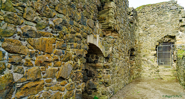
15th or 16th Century
The walls of Dunure Castle, The site dates from the late 13th century; the earliest charter for the lands dating from 1256, but the remains of the building are of 15th- and 16th-century origin. (Wikipedia)
Well over 500 years which ever it was!
In 16.9 so a large view may better, anyway HWW to all!
Jump to top
- ipernity © 2007-2025
- Help & Contact
|
Club news
|
About ipernity
|
History |
ipernity Club & Prices |
Guide of good conduct
Donate | Group guidelines | Privacy policy | Terms of use | Statutes | In memoria -
Facebook
Twitter


